Valley connector
A functional crossing where the role in the landscape matters
The Col de la Croix de Fer is one of the great Alpine classics: long, irregular, scenic, and deeply tied to Tour de France history. Linking the Maurienne valley with Oisans, it sits just east of its close neighbor, the Col du Glandon, with which it shares much of its approach from the west.
At 2,067 m, it is not the highest Alpine pass, but its length, changing gradients and exposed final kilometers give it a serious high‑mountain feel.
The Croix de Fer is defined less by constant steepness than by its constantly changing rhythm, testing pacing, patience and endurance.
Why ride the Col de la Croix de Fer?
- Classic Tour credentials without the extreme crowds of higher passes
- Exceptionally varied terrain, forcing constant adaptation
- Multiple iconic combinations, especially with the Col du Glandon
- Outstanding alpine scenery, from dams and waterfalls to open pasture
- A thinking rider’s climb: pacing and restraint matter more than brute force
The Croix de Fer rewards riders who enjoy complexity rather than uniform suffering.
Seasonal notes
The Col de la Croix de Fer is closed in winter due to snow and avalanche risk. It typically reopens in mid to late May and usually closes again in early November. Opening and closing dates may differ between the Maurienne and Oisans sides.
Even in summer, weather can change quickly. Temperatures at the summit are cooler than in the valleys, and fog, wind or storms can develop rapidly. Early‑season riding may involve meltwater, gravel and lingering snowbanks near the top.
Always check live road conditions with Savoie Route or Isère road services before riding.
Tour de France
The Col de la Croix de Fer has featured in the Tour de France 21 times since 1947, most recently in 2022.
In 2015 it was included in 2 stages: stage 19 via the Col du Glandon from la Chambre and stage 20 from Saint-Jean-de-Maurienne.
The latter stage was the result of an alteration, since the original stage route over the Télégraphe / Galibier was blocked because a landslide had made descending the Lautaret impossible.
In stage 18, the climb from Rochetaillée was included too, but that took the left turn over the Glandon…
Maurienne vs Oisans
The Col de la Croix de Fer offers two very different riding experiences and depending on whether you approach from the Maurienne or Oisans, the character of the climb, the scenery, and the physical demands vary significantly.
Ideally, the Croix de Fer is a pass to be ridden from both sides. Each reveals a different personality of the mountain, and together they explain why this col has remained a Tour de France fixture for decades.
Maurienne
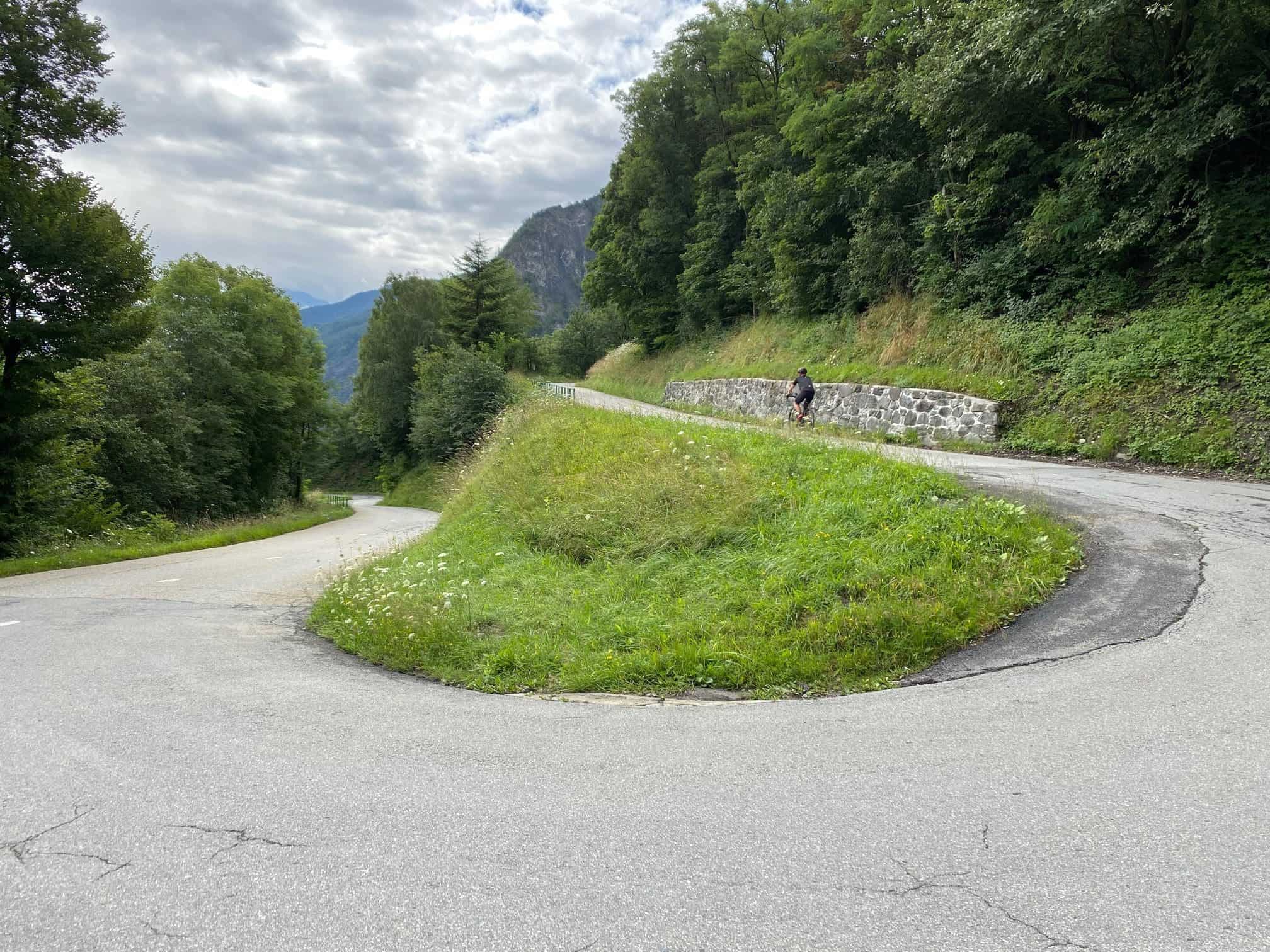
The approach from Saint‑Jean‑de‑Maurienne is the classic Croix de Fer and the side most closely associated with the Tour de France. It is long without ever feeling straightforward. Short descents, changes in gradient, and repeated ramps above 8–9% constantly disrupt rhythm and punish poor pacing.
This side rewards riders who can adapt effort repeatedly rather than settle into a steady tempo. While the gradients are rarely extreme for long periods, the cumulative fatigue can be surprising, especially in the final kilometres as the road opens into high alpine pasture near the summit.
If you enjoy climbs that demand tactical thinking and patience, the Maurienne approach is the more mentally engaging of the two.
Oisans
From Rochetaillée, the Croix de Fer is part of a much larger alpine journey. The climb shares its approach almost entirely with the Col du Glandon, passing dramatic reservoirs such as Lac du Verney and Lac de Grand’Maison before reaching the high plateau. Only in the final 2–3 km does the route diverge toward the Croix de Fer summit.
This side feels more open and expansive, with longer stretches of consistent climbing and fewer abrupt changes in gradient. While still demanding, it lends itself better to a steady endurance pace and suits riders who prefer rhythm over repeated accelerations.
The scenery is more dramatic and varied than the north side, making this approach especially popular for long alpine days and loop rides.
Saint-Jean-de-Maurienne
This end is long and irregular, with short descents and steep ramps that disrupt rhythm. It climbs steadily through the Arvan valley before emerging into open alpine pasture near the summit.
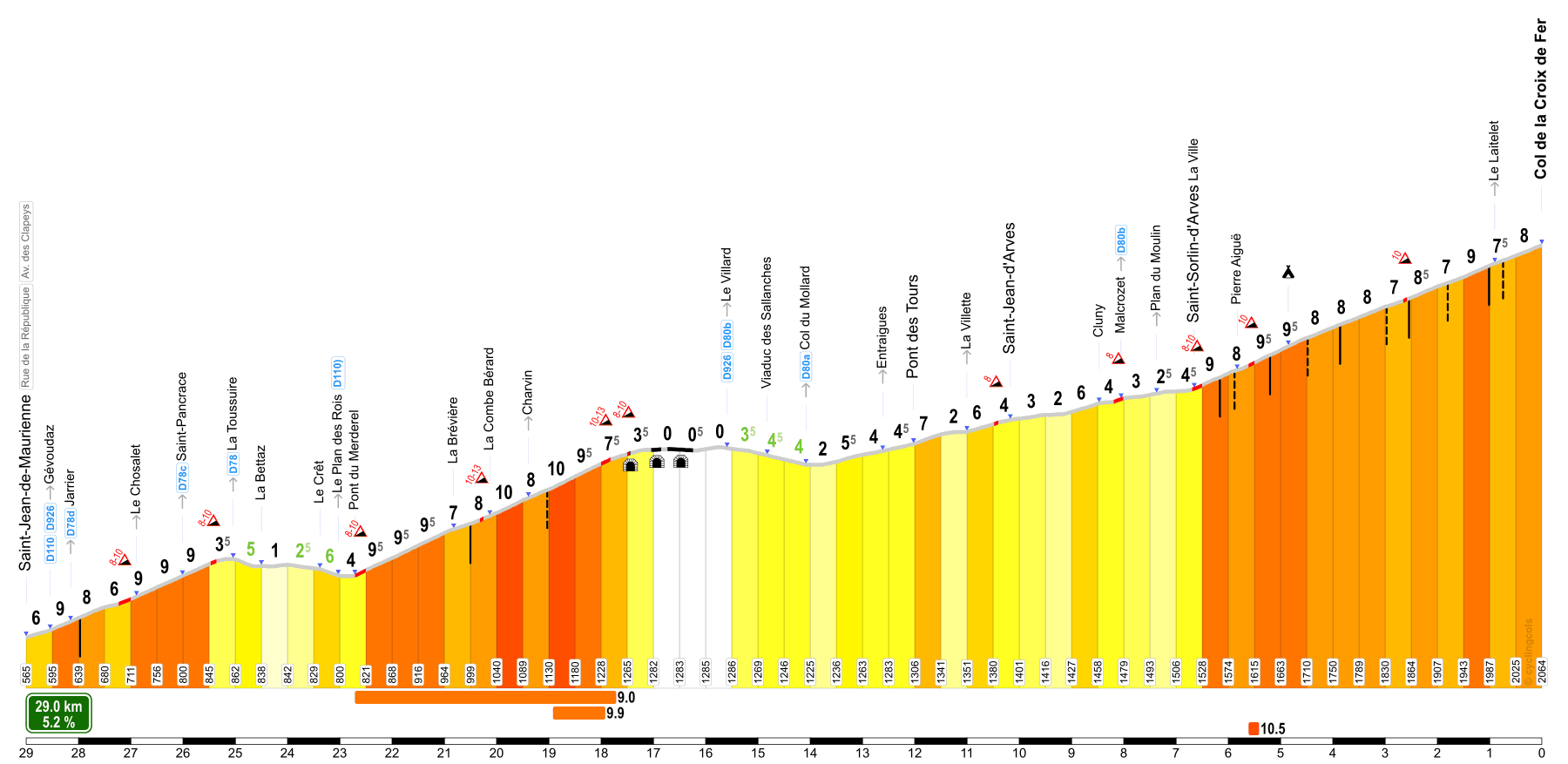
It’s 29 km long with an average gradient of 5.2%, but without the flatter sections and short descents, the climbing parts’ average is around 8.7%.
Route Panoramique
Just past a series of 3 tunnels, you can take a scenic detour from the classic route. Take the right turn over the D80B, direction Saint-Jean-d’Arves, labeled “Route Panoramique” – it rejoins the “classic” route at Malcrozet.
At the summit of the Col de la Croix de Fer, there’s a restaurant and souvenir shop, serving a mean homemade blueberry pie 😋
Bike Rebel Ascents
I barely managed this ascend in 2012, when I was recovering from a bad crash.
During my Tour de France 2021 it was in stage 4 and via the Route Panoramique in my epilogue, in 2022’s Tour it was my epilogue again.
I did get up the Croix de Fer in 2024 too, but that was with a “detour” up and down La Toussuire first.
Rochetaillée
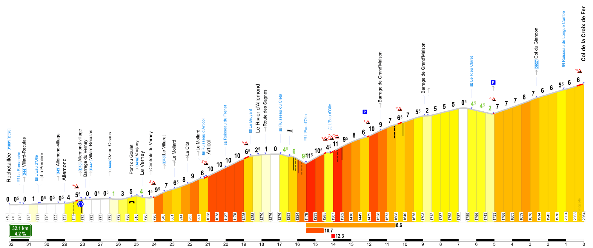
After a flat warm up of some 3.5 kilometers and a short sprint up the barrage du Verney, the actual climb starts: 29 kilometers in length, with a moderate average gradient of 5.1%.
However, this end has a serious drop and 13 kilometers with no net elevation gain. Taking this into consideration, the average climbing gradient rises to around 8.3%.
This drop is due to a 1989 landslide that swept away the road on the right bank of the Eau d’Olle above Le Rivier d’Allemond at the Maupas waterfall. The road was then rebuilt on the left bank, the hairpins going down to the river crossing.
Note: when you descend the Croix de Fer to Allemont, the hairpin section from the Olle up to Le Rivier actually has a segment of its own, La Côte des Sagnes, marked in the map above.
About 3 kilometers before the summit, you’ll pass the left turn up the final 200 meters of the Glandon and in the “home stretch” to the Croix de Fer summit, the (cold) wind can make it quite hard.
Bike Rebel Ascents
I climbed this end in 2014 and during in 2021, the Croix de Fer was combined with the Mollard in my prologue.
During my Tour de France 2022, I cycled this end from Allemond as part of my Marmotte and from Le Verney in stage 6, after I cycled up and down the Col du Sabot.
However, I turned left at the Glandon split on both occasions.
Col du Glandon
Two-sided contrast
The differences between approaches define the climb’s identity
The Col du Glandon forms part of a two‑pass system with the nearby Col de la Croix de Fer, and the two are often treated as interchangeable.
They are not.
If you look at the Glandon seperately, it has two completely different climb profiles. The appoach from Rochetaillée is the same as the Croix de Fer’s, it just ends earlier.
The approach from Saint‑Étienne‑de‑Cuines gives the climb a very different character compared to the more open Croix de Fer.
This ascent:
- is more enclosed by forest
- climbs through sequences of tight, repetitive hairpins
- builds elevation in a more concentrated and visible way
It is a climb where the road itself—through forest, bends, and repetition—shapes the experience more than the broader landscape.
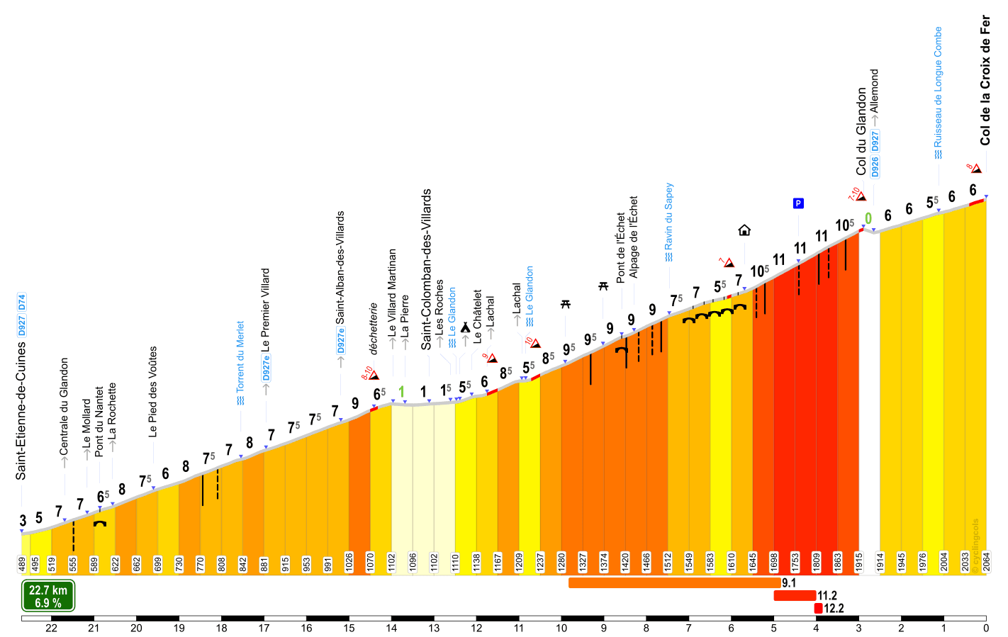
The wide-open final 2.5 kilometers of the Glandon are often referred to as “hairpin heaven”, but they are also painfully steep, averaging 11%. The summit, at 1,925m, connects to the Croix de Fer for the final ~2.5 kms from the Rochetaillee ascend.
There’s no refuge, but there is a little shed which offers refreshments – but nothing freshly made – if open. I’ve only seen it open once, in 2022, and the English lady tending it was very friendly.
I rode up to the summit of the Glandon from this end on my way to our one night stopover near Vaujany in 2014 and again in 2021 during stage 2.

Col du Mollard
Another route up the Col de la Croix de Fer leads over the Col du Mollard (1,638m).
This is not an alternative like the Glandon, as the Mollard’s summit is not close to that of the Croix de Fer.
In fact, the course in the opposite direction, i.e. down from the summit of the Croix de Fer and then up and down the Mollard to Saint-Jean-de-Maurienne, is an alternative the Tour de France has taken on a few occasions, after which the peloton continued on to Saint-Michel-de-Maurienne for the Télégraphe / Galibier.
You can choose to take the D110 out of Saint-Jean-de-Maurienne or start in Villargondran and take the D80.
D80
The 17.7 kilometers long ascent over the D80 averages 5.8%, is irregular between le-Jeune and le-Vieux, but only has a few stretches that are steeper.
This is also the route with an abundance of hairpins – I tried counting, lost count at 36 but Climbfinder states there are 45…
You get a “free” col marker when reaching Albiez-le-Jeune, the Col de la Confrérie (1,368m).
D110
Cycling the D110, the Mollard is 15.7 kilometers long, at an average gradient of 6.6%, although two-thirds of it is close to 8%.
The two routes join at Albiez-le-Vieux for the final kilometer to the Molard summit.
Croix de Fer Remainder
As stated, the summit of the Mollard is not close to that of the Croix de Fer.
First, you descend around 6 kilometers back to the Croix de Fer route (D926) – in the opposite direction the climb averages 6.8%.
From where you join the D926, it’s 14 kilometers at 6% to the summit of the Croix de Fer, as shown in its profile card from Saint-Jean-de-Maurienne above.
I tackled the Mollard twice during my Tour de France 2021: from Montrond in my prologue, and from Villargondran in stage 6.